Contents
Index
Adding Reference Mark Data to a Point
It is often convenient to omit reference marks during the parcel data entry as many of these marks may not be needed.
This option will generate a reference mark point and a connection to a selected point in the parcel network.
To include this Tool in Geocadastre, there has to be the following entry in the MenuColumn section of the Config file.
menuEntry menuText="Point Ref Data" menuItem="MENU_POINT_REF_DATA"
The change to the config file can be made using a text editor.
Running the process
Select the "Point Ref Data" tool from the "Extra Tools" list.
The following dialogue will be displayed
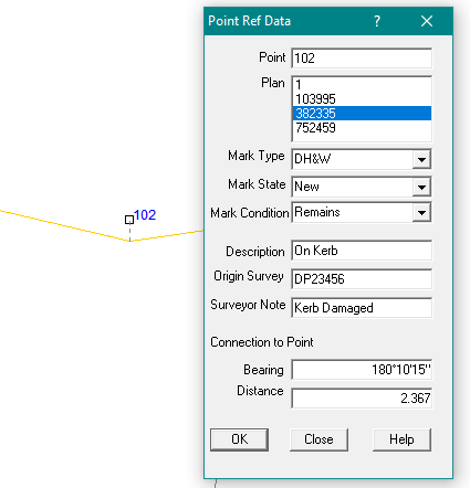
Use the mouse to select the point requiring a reference mark:
The point number will be displayed in the top window.
Using the drop down list, select the plan to be used.
This is necessary because a point may exist on multiple plans.
The mark type, state and condition can be selected using the drop down lists.
A description, Origin Survey and surveyors note can be added if required.
The connection details can then be added and these should be exactly the same as shown on the cadastral survey plan.
When the "OK" button is hit, a connection will be added to the selected point in the selected plan.
As survey plans always show reference mark connections to go from the RM to the corner, the bearing of the connection will be reversed.
A new point will be created at the end of the connection and this point will be a reference mark with all the attributes from the dialogue box.
The fields in the dialogue box will then be cleared to await the selection of the next point.